General framework
The following is a summary of key results achieved under the “Plan of Management and Urban and Regional Development and Local Development Strategies for the Municipality of Lobos, Buenos Aires Province”, Study 1.EE.304 Multi-sectorial Pre-investment Program III, with the Inter-American Development Bank´s (IDB) funding, BID Loan 1896/OC-AR.
The Consultant Team´s task required by Lobos municipal council consisted in the formulation and implementation of a strategic plan that allows the overall development of the region and improves the living conditions of its inhabitants. It must also provide a set of planning and land management instruments that intend to establish urban and regional policies to develop an active role of the municipal council as promoter of sustainable economic development.

Consultant team
Executive Coordination
PhD. Arch. Guillermo Tella
Urban Development
Arch. Martín Delucchi
Arch. Manuel Ludueña
Programs and Projects
Arch. Jorge Pasín
Environmental Assessment
Lic. (Amb) Marcelo Somenson
Urban Regulations
Arch. Claudia Rodríguez
Local Development
Lic. (Geog) Diego Rodríguez
Lic. (Econ) Gustavo Mosto
Cartographic Production
Lic. (Geog) Silvina Fernández
Technical Assistance
Lic. (Urb) Daniela Natale
Lic. (Urb) Estela Cañellas
Lic. (Urb) Alejandra Potocko


How to plan for growth
Lobos, a predominantly rural municipality, is affected by a situation of interface between the expansion of the metropolitan area of Buenos Aires and the rural hinterland. That given scenario addresses the challenge of giving value to pre-existing elements, ordering displacements and guiding future growth. From this perspective, the Lobos municipal council developed the “Lobos 2020 Strategic Plan”.
In Argentina, the municipality of Lobos is located one hundred kilometers southwest of Buenos Aires City. It is characterized by plains, depressions and lagoons. It has a population of 33 thousand inhabitants and an urban system consisting of a head city, Lobos (which accounts for 90% of the population), and a series of scattered small towns: Antonio Carboni, Elvira, VillaLogüercio, Salvador María and Zapiola.
It is predominantly rural and integrates the Salado River basin. The City of Lobos is an important trade and business centre in the regional scale, favored by its high accessibility through the Provincial Route 41 and the National Route 205. The City of Lobos is also the epicenter of the industrial activity in the municipality. It has significant resources of historical and cultural value in the central area, such as argentine president
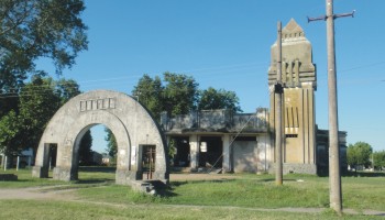
Juan D. Peron’s Birthplace.
Lobos undergoes metropolitan strains (related to real state, jobs and commerce), as well as environmental stresses (floods, water quality, disposal of effluents in water canals). The pre-eminence of rural activity and the existence of natural resourses and landscape show a state of transformation of the environment that must be preserved to enhance production and responsible tourism.


Competitiveness and growth
The municipality of Lobos is characterized by the decrease of rural population and the evident primacy of the City of Lobos over the other scattered towns due to its particular transportation system, infrastructure and equipment. It also shows a progressive inclusion to the metropolitan process of conurbation of Buenos Aires, as a dormitory city and a supplier of industrial, agricultural and livestock products.
In this context, the challenge taken by the municipal council was regarding how to generate development adapted to the conditions of predominance of rurality with an important urban centrality, the City of Lobos, accessible and with a tendency to urbanize rural areas. Thus, the objectives to reach were: to promote competitiveness in the area, to generate sustainable growth and to contribute to social inclusion.
Under those basic premises various strategies were developed to guide growth:
● Macro-regional Strategies: to promote common guidelines between neighboring municipalities, concerning the protection of rural heritage and the environmental biodiversity, pressures generated on the natural groundwater resources and the
dominant natural landscape.
● Inter-district Strategies: to promote complementarities between the districts of Elvira and Antonio Carboni, the functional connection between Zapiola and Empalme, and the integration of actions between Salvador María, Bahía de Lobos
and VillaLogüercio.
● Intra-urban Strategies: to promote the compactness of the urban fabric, limiting the growth of downtown Lobos, strengthening the area of Empalme as a sub-center and the creation of a new centrality in the Terminal area.


The agreed ordering model
From this formulation, an ordering model was agreed between the local government and the local society. The model is aimed at: preventing the uprooting of population living in the towns of the interior districts, preserving the most fragile natural areas, limiting any concentration of activities whose effects could compromise groundwater´s quality and generate soil degradation, and regulating the comprehensive management of the Lobos lagoon.
We propose the creation of the Lobos Recreational Green Circuit that threads antiquated railway spaces of Empalme Lobos-Elvira railway line, the Salado riverbanks, the road to Salvador María, the banks of the Lobos lagoon and the Green Corridor of Salgadowater canal. Limits are also set on certain land uses in rural areas, such as feet lots, country clubs, golf courses, peri-urban cellars.
For the City of Lobos, the ordering model prioritizes: to upgrade provision of basic infrastructure, to generate the urban subcenters of “Empalme Lobos” (Lobos Junction) and “Vidriera de Lobos” (Window of Lobos), to improve the quality of the central urban area and its relationship with the lagoon, to protect and strengthen local cultural heritage, to improve the city´s circulatory structure and accessibility´s hierarchy, and to recover the environmental value of the territory.
It is also defined an industrial area, exclusive for the engineering sector, an agricultural and livestock industrial pole, and a “Textile Plant” to add value with local design. Finally, superficial watercourses are protected and the “Water Park” is created as a public, educational and recreational space that helps to recover the symbolic value of water as a resource.


Plan´s foundational strategies
From the vast array of emerging proposals, ten strategies regarded as the founding of the plan are summarized below:
● Strategy 1: Productive Strengthening
It promotes production growth throughout taxation instruments that mobilize the industrial market, the development of a “Textile Plant” to add local value, the creation of an agricultural and livestock industrial
pole to develope a metalworking district that groups local industry, among others.
● Strategy 2: Regional Articulation
It comprises a set of actions aimed at generating a “Green Circuit” that links small rural towns, the farms, the lagoons and the Salado River, complementarity between districts for the development of productive projects, the designation of areas of intangible value or of natural reserve, among others.
● Strategy 3: Rural Tramway Lobos
It proposes the creation of a diesel train service linking all the districts of the municipality, from infrastructure and railway lines now decommissioned and/or underutilized. It is for touristic attraction -as it connects farms and homesteads- and allows transportation of supplies in a boxcar.
● Strategy 4: Territorial Qualification
It promotes the integration of the urban fabric of the city of Lobos through completion of its interstices, the dissolution of urban barriers, the relocation of engineering industries, the recovery of degraded
areas, decommissioning and relocation of silos, the creation of the a “Water Park”, etc.
● Strategy 5: New Centralities
It develops two urban sub-centers in the City of Lobos: “Empalme Lobos” on one end throughout the re-functioning and valorisation of the Empalme railway station and the recycling of derelict industrial plants, and “Vidriera de Lobos” on the other one, over an area to be developed through a public-private consortium.
● Strategy 6: Road Hierarchy
It tends to improve the accessibility to the City of Lobos and its internal connectivity through the creation of differential roads for car traffic and loads, the creation of a “Cargo Transfer Center and of Goods in Transit”, the complementarity between transport system and a new bus terminal, etc.
● Strategy 7: Urban Revitalization
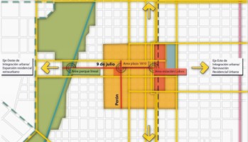
It seeks to restore the central area of the city of Lobos, throughout hierarchization of the east-west axis (9 de Julio St.), the valorization of historic places (Lobos Train Station, “Plaza 1810” -central square-, Juan D. Peron´s Birthplace, etc.), the creation of pedestrian touristic circuits and provision of adequate urban facilities.
● Strategy 8: Environmental Sustainability
It promotes the recovery and management of the Lobos lagoon, the restoration and control of urban and peri-urban cellars, the recovery and management of the Salgado Canal, the protection of groundwater and surface water resources, and institutional strengthening to promote environmental comptroller, etc.
● Strategy 9: Legal Instruments
It generates a new “Land Management Code” and a “Building Code”, incorporating mechanisms for citizen participation and management, urban compensations, new procedures for the adoption, implementation
and monitoring of the Plan, tools for environmental and heritage preservation, etc.
● Strategy 10: Systematization of Information
It is the development and operation of a “Land Information System”, which manages spatial data, integrates and articulates the different municipal databases. It involves a process of data collection,
computer processing and map production for constant updating.


He course taken toward the next decade
From the selection of key issues raised mechanisms for consultation and participation, based mainly on the organization and conduction of workshops with local institutions and local society, in order to identify local problems and validate various proposal phases. In this way, at the different outlined stages, participation of different actors was ensured -various agencies and levels of government and social and economic sectors were involved-.
As it undergoes metropolitan strains, related to Buenos Aires’ tendency to advance over a metropolitan territory, a series of defensive actions were generated: to increase competitiveness before production dismantling, to focalize actions based on mitigation and reversibility before environmental fragility. Regarding the regional disruption, actions arise to provide integration between districts, as well as actions toward readjustment and retraining before territorial decompensation of the city.
Consequently, with this strategic positioning, Lobos municipality plans its growth toward the next decade: 2020 is the goal, the plan is on course.


Plan objectives
► Develop a plan for territorial development
► Define the positioning of the Lobos Municipality
► Develop strategies for local development
► Build an ordering model
► Create a system for citizen participation
► Develop tools for urban management
► Promote sustainable economic development
► Develop priority programs and projects
► Develop a policy framework for urban form
► Computerize an information system
The current scenario
Lobos is located in the central-southeastern region of Buenos Aires Province, at 102 km from Buenos Aires City and 125 km from La Plata City (capital of the Province). It borders the Municipalities of Las Heras to the North, San Miguel del Monte and part of Cañuelas to the East, Navarro to the West and Roque Perez and 25 de Mayo to the South.
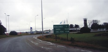
It has a very good accessibility: Ezeiza-Cañuelas Highway links the municipality with the City of Buenos Aires. National Route 205 is the main road of the municipality, which crosses from east to west, and the Provincial Route 4, going North-South, communicates the head city of Lobos with neighbouring towns.
The municipality of Lobos is crossed by two railway lines, which intersect at the so-called “Empalme Lobos”, located on the northern edge of the city of Lobos. These two lines were part of the extensive network of railroads that were built during the nineteenth century in order to move products from the countryside to the port of Buenos Aires, before being exported.
The Municipality of Lobos has a total area of 1.7 thousand km2 and has a population of 33 thousand inhabitants (19 inhabitants per km2). It is geographically defined as plain with some depressions (maximum height is 36 meters above sea level) suitable for agricultural and livestock production. It has several lagoons and one of its boundaries is the Salado River.


General characteristics
Lobos, the head city of the municipality, accounts for 90% of its total population. The other urban centres are defined by the following towns: Salvador María, Villa Logüercio, Elvira, Antonio Carboni and Zapiola. The predominant economic activity is agricultural production.
It also develops a tourism activity known as “countryside tourism”, which is based on the re-functioning of old homesteads. The mini tourism development is given mainly by the Lobos lagoon, which is the main local attraction, as well as from the practice of some sports like polo, golf, skydiving and aviation.
The industrial activity and associated employment are less relevant, being preeminent services related to construction, the metal mechanical sector, food and clothing industries. There are about a thousand exploitations that occupy 95% of the total area of the municipality (78% of the plants are operated by their owners).
Since 1995, the municipality has integrated a productive corridor called Common Growth Area, which is also integrated by the municipalities of 25 de Mayo, Saladillo, Roque Perez, Bolivar, Tapalqué and General Alvear. During the last decades, this potential development has been affected by flooding and drought cycles that hinder economic and social development of its inhabitants.


Diagnostic evaluation
Lobos is affected by a situation of interface between the expansion of the metropolitan area of Buenos Aires and the rural hinterland. From this perspective, we understand the current scenario as:
– Oflocal support, defined by its rural production basis, where the railway system deactivation limited its growth and the City strengthened its foundational characteristics as a centre of services
for rural areas.
– Of regional membership, given its insertion in the Salado River Basin, its livestock and forestry production abilities, its chained system of lagoons and its conditions of vulnerability.


Definition of the profile
Overall, the municipality´s profile in its regional insertion can be summarized in the following:
► Agricultural production development
• Predominance of the traditional activity
• Capitalization of comparative advantages
• Potential for regional integration
► Agro industrial development
• Hegemony of small businesses
• Demand for intensive labor
• Encouraging of a high level of informality
► Tourist Development
• Diversity of natural and cultural attractions
• Market segmentation by social sectors
• Potential to develop differentiated offerings
Consequently, the challenge is to generate development adapted to the conditions of predominance of rurality with an important urban centrality, the City of Lobos, accessible and with a tendency to urbanize rural areas. Thus, arises:
•To promote the competitiveness of the area
•To generate sustainable growth
•To contribute to social inclusion


Prospective scenarios
From competitiveness, growth and inclusion perspectives emerge four scenarios as prospective alternatives, from which it was possible to take a position to define later the proposal´s ordering criteria:
a. Industrial Expansion Scenario: Abrupt transformation of rural land for location of secondary activities (transformational).
b. Residential Growth Scenario: High consumption of rural land and lacustrine environment for the introduction of urban housing.
c. Insular Development Scenario: Speculative occupation of production land for the development of gated urbanizations.
d. Regional Balance Scenario: Capitalization and articulation of rural, urban, cultural, industrial and tourism qualities.
From the motivations discussed with the local government and the expectations generated in the local community, the scenario that was finally prioritized and in which the plan is based on, is the one that promotes regional balance to articulate and enhance the pre-existing elements.


Ordering criteria
To limit urban growth (to service covered area)
To promote the completion and consolidation of the urban tissue
To create territorial sub centers (“Empalme”+”Terminal”)
To generate production nodes (“Agropolo”+”Textile Plant”)
To generate a hierarchical road network
To form an urban green system (public and integrated)
To recover water as a resource and as symbolic value


The territorial model
The territorial model developed for Lobos poses as central problems the poor coordination between routes and road access to urban centers, a deficient road hierarchy, the absence of a separate road network for loads transport, and the lack of connection and linkage between different neighborhoods.
Moreover, there has been an increase in rural land price of 9 to 75 times; due to the tangible value given to natural landscape and the adequacy of production units for the development of country clubs, polo fields
and rural tourism.
The increase in land value reflected in the local community as an enclave which establishes new limits to public use of lagoons and waterways. Furthermore, several of the expected changes produced through the implementation of these developments could be an opportunity, but they require essentially a vision that avoids environmental costs to the water basin and economic costs to the society; and these should necessarily be addressed in the short term through agreements and compensation measures.
A synthesis of the territorial model in its two levels of understanding -local support and regional membership- could be summarized as the following:
a. on the one hand, local support: the rural production base, the districts and infrastructure, railway transportation and road implantation.
b. on the other hand, regional membership: the Salado River Basin, the tensions with the Buenos Aires metropolitan area and the Common Growth Area.


The lines of action
The territorial imbalances observed from the standpoint of providing services and infrastructure, involve a waste of endogenous development potential and the unequal distribution of wealth. Therefore, the actions tend to articulate with a balanced territorial development approach:
a. Development and integration of the rural districts of the municipality and reactivation of degraded areas (degraded because of the deactivation of territorial structuring activities, such as Empalme Lobos).
b. The need to limit the growth of the urban area, discouraging sprawl, which has had an increasing difficulty for the provision of urban services.
In this context of situation, as initial approach to the problems discussed, a management model was developed, that seeks to give value to pre-existing elements, order displacements and guide future growth.
It also emphasizes environmental sensitivity in the provision of services and infrastructure and equipment, in revitalizing the business sector as well as preserving the natural landscape and cultural heritage.
As a result, a number of strategies were generated, of macro-regional, inter-and intra-urban characteristics. These strategies will allow the definition of policies, Priority Programs and specific Projects.


The proposed strategies
Some of the problems identified at the territorial level, concerning the whole municipality, are related to an uneven development of districts expressed by the distribution of infrastructure, basic services and equipment and differences in accessibility. In the urban scale (City of Lobos), also with an unequal distribution of infrastructure and basic services, main problems are the growth of the urban area in low density and the increasing difficulty in providing services, the conflicts generated between land uses, particularly among industrial and residential uses and environmental problems.
The territorial imbalances observed involve the loss of endogenous development potential and an unequal distribution of wealth. Therefore, local development proposals must be coordinated with regional urban development objectives expressed at the territorial level by:
-Development and integration of the rural districts of the Municipality and reactivation of degraded areas (degraded because of the deactivation of territorial structuring activities, such as Empalme Lobos).
-The need to limit the growth of the urban area, discouraging sprawl, which has had an increasing difficulty for the provision of urban services.
A proposal for a “more sustainable development”, encompassing long-term vision, also implies actions at municipal, city level and management level. Then, the proposed territorial strategies are organized
into three levels:
a. Macro-regional Strategies: to promote common guidelines between neighboring municipalities, concerning the protection of rural heritage, the environmental biodiversity, pressures generated on the natural groundwater resources and on the dominant natural landscape.
b. Inter-district Strategies: to promote complementarities between the districts of Elvira and Antonio Carboni, the functional connection between Zapiola and Empalme, and the integration of actions between Salvador María, Bahía de Lobos and Villa Logüercio.
c. Intra-urban Strategies: to promote the compactness of the urban fabric, limiting the growth of downtown Lobos, strengthening the area of Empalme as a subcenter and the creation of a new centrality
in the Terminal area.


The priority programs
Under the diagnostic analysis made and local and urban development strategies proposed for the head city and the rest of the districts in the Municipality, arise a series of Priority Programs and their emerging Urban
Projects.
The first program is linked to local development, which propounds the generation of a virtuous circle of economic growth, improved incomes, improved quality of life of people and retention of this population in the area.
The Central Area Revitalization Program includes several projects: the restoration of urban heritage, the creation of historic protection areas, the development of pedestrian tourist circuits, a linear park in Salgado and Muñiz Canals, relocation and/or re-functioning of activities and buildings responding to the requests that have been detected within the area.
A Program for the Development of New Centralities is proposed, linked to the Sector Plans for Empalme Lobos and for a lot located at the crossroads of routes N° 205 and N° 41. The Program for the Extension of the Infrastructure Network should contain all the projects and initiatives referred to gas networks, electric power, water, sewers and drainage, pavements and street lighting.
It is as well of deep interest to develop an Accessibility and Mobility Program, for the traffic and linkage differentiation in order to facilitate mobility in the Municipality. It is also proposed a Program for the Strengthening of the Rural Districts, which is based on the necessary revitalization of railway system.
The Program of Environmental Sustainability and Value of Land and Water Defense is associated with the recovery of cellars and the treatment of the Lobos Lagoon, as well as other similar aspects that may arise.
Another program required is addressed at solving problems of Habitat, Housing and Community Facilities, including housing for the Empalme Lobos intruders, in order to reuse these facilities. In summary, the
Priority Programs on which the Plan is uphold are:
► Lobos Local Sustainable Development
• Promotion of work, employment and production
• Promotion of meat-milk production integration
• Formation of companies networks and supply chains
• Promotion of industrial location policies
• Creation of a agricultural and livestock industrial pole
• Development of the “Textile Plant” (training and design)
► Strengthening of Local Institutions Program
• Fiscal instruments for raising resources
• Taxation of new enterprises
• Instruments for recovery of capital gains
• Purchase of strategic land lots for urban planning
• Deepen the territorial marketing strategy
• Generating a municipal land bank
► Central Area Revitalization Program
• Recovery of Urban Heritage
• Creation of historic protection areas
• Development of pedestrian tourist circuits
• Generation of linear parks on streams
• Creation of a Water Park on Salgado Canal
► Development of New Centralities Program
• Sub-center in the area of Empalme Lobos
• Sub-center at the intersection of Routes 205 and 41
► Extension of the Infrastructure Network
• Extension of gas networks, electricity, water, sewers
• Expansion and improvement of pavement and street
► Accessibility and Mobility Program
• Development of the transit network by modes
• Development of new access and road linkages
► Strengthening of the Rural Districts Program
• Associative actions to even the provision of services
• Development of a Tramway using existing railways
► Value of Land and Water Defense Program
• Cellars recovery and treatment of the Lobos Lagoon
• Recovery of the symbolic value of resource water
► Habitat, Housing and Community Facilities
• Improvement of habitat conditions
• Generating social housing for new families


The executive projects
In this line of action, Executive Projects have been developed –in accordance with the local government´s cabinet- to be implemented gradually during the period 2010-2020.
more info